

 The Council Creek Regional Trail is a collaboration between:
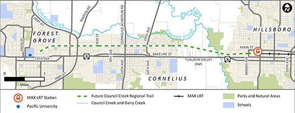
The Council Creek Regional Trail master plan was prepared in 2015. This plan includes the a future route of the planned 15-mile trail between the Hatfield MAX station in downtown Hillsboro and the Banks-Vernonia trailhead in Banks.
Our planning process included public comment opportunities through online and in-person open houses and tables at community events.
Based on community input, we plan to build a trail that:
Only the 6-mile segment between Hillsboro and Forest Grove has been funded. This segment follows an abandoned train line. The tracks for the line were removed last year in preparation for this project. Following the existing route makes construction easier and avoids environmentally sensitive areas.
This open house looks at the proposed safety enhancements we plan to add at the street crossings on the initial trail segment.